![](/images/other/stat-length.png)
![Randonnée A pied Gemeinde Scheffau am Wilden Kaiser - Hintersteinersee Runde - Photo](https://media.geolcdn.com/t/1900/400/ext.pjpeg?maxdim=2&url=https%3A%2F%2Fmedia.geolcdn.com%2Ff%2F7ce82edb-c501-4d03-be1c-122723060ba0.jpeg)
Hintersteinersee Runde
SityTrail - itinéraires balisés pédestres
Tous les sentiers balisés d’Europe PRO
![Longueur](/images/other/stat-length.png)
Longueur
5,2 km
![Altitude max](https://static1.geolcdn.com/siteimages/upload/files/1508320355ic_sort_altitude_max_24dp.png)
Altitude max
947 m
![Dénivelé positif](https://static1.geolcdn.com/siteimages/upload/files/1508320355ic_sort_den_pos_24dp.png)
Dénivelé positif
128 m
![Km-Effort](/images/other/stat-length.png)
Km-Effort
6,9 km
![Altitude min](https://static1.geolcdn.com/siteimages/upload/files/1508320355ic_sort_altitude_min_24dp.png)
Altitude min
882 m
![Dénivelé négatif](https://static1.geolcdn.com/siteimages/upload/files/1508320355ic_sort_den_neg_24dp.png)
Dénivelé négatif
133 m
![Boucle](https://static1.geolcdn.com/siteimages/upload/files/16400158638029165_repeat_loop_refresh_sync_direction_icon.png)
Boucle
Oui
Balise
Date de création :
2022-02-16 17:00:52.013
Dernière modification :
2022-03-03 15:27:47.891
![A pied](https://static1.geolcdn.com/sitytour/trail-icons/100.png)
1h33
Difficulté : Facile
![Scannez ce code QR pour ouvrir la randonnée dans l'application SityTrail](https://capi.geolives.com/qq0zvz2zws4bq2lad0pu/sitytour/trails/3128564/qr.png?size=200)
Application GPS de randonnée GRATUITE
À propos
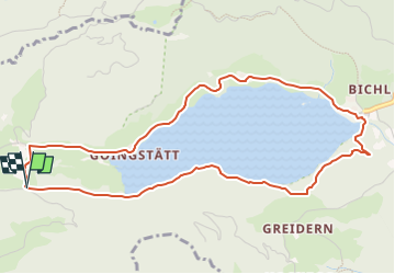
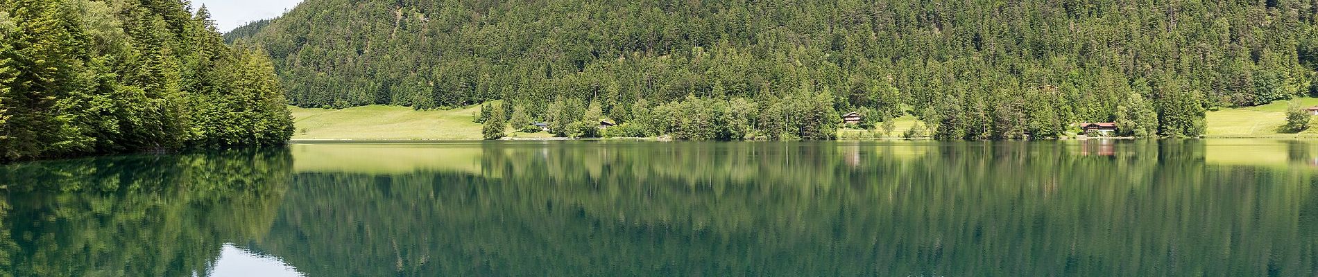
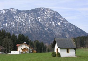
Randonnée A pied de 5,2 km à découvrir à Tyrol, Bezirk Kufstein, Gemeinde Scheffau am Wilden Kaiser. Cette randonnée est proposée par SityTrail - itinéraires balisés pédestres.
Description
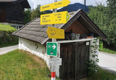
Symbole: Weiße Schilder mit rotem Richtungspfeil und gelbem Streifen mit dem Namen "Hintersteinersee Runde"
Localisation
Pays :
Autriche
Région :
Tyrol
Département/Province :
Bezirk Kufstein
Commune :
Gemeinde Scheffau am Wilden Kaiser
Localité :
Unknown
Départ:(Dec)
Départ:(UTM)
289072 ; 5268809 (33T) N.
Commentaires
Randonnées à proximité
![Randonnée A pied Stadt Kufstein - Denkmalwanderung - Photo](https://media.geolcdn.com/t/375/260/ext.jpg?maxdim=2&url=https%3A%2F%2Fmedia.geolcdn.com%2Ff%2F050b7c40-79f2-444c-adf3-bc878881d4c9.jpeg)
![A pied A pied](https://static1.geolcdn.com/sitytour/trail-icons/100.png)
Denkmalwanderung
A pied
Facile
Stadt Kufstein,
Tyrol,
Bezirk Kufstein,
Autriche
![](/images/other/stat-length.png)
5,7 km | 7 km-effort
1h 36min
![](https://static1.geolcdn.com/siteimages/upload/files/16400158638029165_repeat_loop_refresh_sync_direction_icon.png)
Oui
![Randonnée A pied Stadt Kufstein - Energieweg Kufstein - Photo](https://media.geolcdn.com/t/375/260/ext.jpg?maxdim=2&url=https%3A%2F%2Fmedia.geolcdn.com%2Ff%2F768c9069-4cc0-4c9d-965e-70eff8e8e6d4.jpeg)
![A pied A pied](https://static1.geolcdn.com/sitytour/trail-icons/100.png)
Energieweg Kufstein
A pied
Facile
Stadt Kufstein,
Tyrol,
Bezirk Kufstein,
Autriche
![](/images/other/stat-length.png)
3,2 km | 6,4 km-effort
1h 27min
![](https://static1.geolcdn.com/siteimages/upload/files/16400158638029165_repeat_loop_refresh_sync_direction_icon.png)
Non
![Randonnée A pied Stadt Kufstein - Elfenhain-Trail - Photo](https://media.geolcdn.com/t/375/260/ext.jpg?maxdim=2&url=https%3A%2F%2Fmedia.geolcdn.com%2Ff%2Fbf877ae3-7b85-40db-872a-fc43df081ae7.jpeg)
![A pied A pied](https://static1.geolcdn.com/sitytour/trail-icons/100.png)
Elfenhain-Trail
A pied
Facile
Stadt Kufstein,
Tyrol,
Bezirk Kufstein,
Autriche
![](/images/other/stat-length.png)
4,8 km | 8,9 km-effort
2h 1min
![](https://static1.geolcdn.com/siteimages/upload/files/16400158638029165_repeat_loop_refresh_sync_direction_icon.png)
Oui
![Randonnée A pied Stadt Kufstein - Brentenjoch-Trail - Photo](https://media.geolcdn.com/t/375/260/ext.jpg?maxdim=2&url=https%3A%2F%2Fmedia.geolcdn.com%2Ff%2F1c6a7877-1f15-44ce-859e-d53183c65a67.jpeg)
![A pied A pied](https://static1.geolcdn.com/sitytour/trail-icons/100.png)
Brentenjoch-Trail
A pied
Facile
Stadt Kufstein,
Tyrol,
Bezirk Kufstein,
Autriche
![](/images/other/stat-length.png)
9,7 km | 16,8 km-effort
3h 49min
![](https://static1.geolcdn.com/siteimages/upload/files/16400158638029165_repeat_loop_refresh_sync_direction_icon.png)
Non
![Randonnée A pied Gemeinde Scheffau am Wilden Kaiser - Auwaldrunde - Photo](https://media.geolcdn.com/t/375/260/ext.jpg?maxdim=2&url=https%3A%2F%2Fmedia.geolcdn.com%2Ff%2F3a82ec08-361f-407c-b990-092670ab9561.jpeg)
![A pied A pied](https://static1.geolcdn.com/sitytour/trail-icons/100.png)
Auwaldrunde
A pied
Facile
Gemeinde Scheffau am Wilden Kaiser,
Tyrol,
Bezirk Kufstein,
Autriche
![](/images/other/stat-length.png)
7,7 km | 10 km-effort
2h 15min
![](https://static1.geolcdn.com/siteimages/upload/files/16400158638029165_repeat_loop_refresh_sync_direction_icon.png)
Oui
![Randonnée A pied Gemeinde Scheffau am Wilden Kaiser - Blaikenrunde - Photo](https://media.geolcdn.com/t/375/260/ext.jpg?maxdim=2&url=https%3A%2F%2Fmedia.geolcdn.com%2Ff%2Ff62c0da4-e38c-4f86-bb60-08e7cedb9a5c.jpeg)
![A pied A pied](https://static1.geolcdn.com/sitytour/trail-icons/100.png)
Blaikenrunde
A pied
Facile
Gemeinde Scheffau am Wilden Kaiser,
Tyrol,
Bezirk Kufstein,
Autriche
![](/images/other/stat-length.png)
4,6 km | 5,9 km-effort
1h 20min
![](https://static1.geolcdn.com/siteimages/upload/files/16400158638029165_repeat_loop_refresh_sync_direction_icon.png)
Oui
![Randonnée A pied Gemeinde Schwoich - VBA-Runde - Photo](https://media.geolcdn.com/t/375/260/ext.jpg?maxdim=2&url=https%3A%2F%2Fmedia.geolcdn.com%2Ff%2Fa2db4e88-f51b-4cd3-a9a0-def1d3cf7f1b.jpeg)
![A pied A pied](https://static1.geolcdn.com/sitytour/trail-icons/100.png)
VBA-Runde
A pied
Facile
Gemeinde Schwoich,
Tyrol,
Bezirk Kufstein,
Autriche
![](/images/other/stat-length.png)
8 km | 10,6 km-effort
2h 24min
![](https://static1.geolcdn.com/siteimages/upload/files/16400158638029165_repeat_loop_refresh_sync_direction_icon.png)
Non
![Randonnée A pied Gemeinde Schwoich - Waldschönauer Runde - Photo](https://media.geolcdn.com/t/375/260/ext.jpg?maxdim=2&url=https%3A%2F%2Fmedia.geolcdn.com%2Ff%2F611dbb3a-95cb-44c3-b8d9-20a695284e74.jpeg)
![A pied A pied](https://static1.geolcdn.com/sitytour/trail-icons/100.png)
Waldschönauer Runde
A pied
Facile
Gemeinde Schwoich,
Tyrol,
Bezirk Kufstein,
Autriche
![](/images/other/stat-length.png)
7,1 km | 8,9 km-effort
2h 1min
![](https://static1.geolcdn.com/siteimages/upload/files/16400158638029165_repeat_loop_refresh_sync_direction_icon.png)
Oui
![Randonnée A pied Gemeinde Schwoich - Schmieder Runde - Photo](https://media.geolcdn.com/t/375/260/ext.jpg?maxdim=2&url=https%3A%2F%2Fmedia.geolcdn.com%2Ff%2Fb1044541-dd3e-49cc-bd81-37d812d18204.jpeg)
![A pied A pied](https://static1.geolcdn.com/sitytour/trail-icons/100.png)
Schmieder Runde
A pied
Facile
Gemeinde Schwoich,
Tyrol,
Bezirk Kufstein,
Autriche
![](/images/other/stat-length.png)
4,3 km | 5,7 km-effort
1h 17min
![](https://static1.geolcdn.com/siteimages/upload/files/16400158638029165_repeat_loop_refresh_sync_direction_icon.png)
Oui